
In her essay, “A Permanent Temporariness,” Alia Mossallam writes of overcoming fear on Jan. 25, 2011, that first night in Tahrir Square, Cairo, when the lights went out and police began firing into the crowd, causing a stampede. Calls of ithbat — stand still — rippled through the fleeing masses: “I covered my ears and sobbed in fear while shouting over and over, my mouth opening to shout the word in the midst of a thunderous, thousand-voice-strong chant: ‘ITHBAT. ITHBAT. ITHBAT.’ It continued until everyone stopped and remained still. Until the crowd felt strong enough in its unified roar, to attack rather than run from the police.”
The occupation of Tahrir Square, which continued from that night until Egypt’s long-ruling president, Hosni Mubarak, stepped down on February. 11, 2011, was an exercise, too, in overcoming decades of public policy and urban planning that had sought to render urban open spaces inaccessible or even dangerous to would-be protestors.
Mohamed Elshahed, author of “Cairo Since 1900: An Architectural Guide,” writes that under Mubarak, fences were erected in Tahrir Square and open areas subdivided into controllable plots of grass and sidewalks. It was policy and planning “filtered through the harsh lens of state security.” Now, under Gen.-turned-President Abdel Fattah Al Sisi, urban transformations have taken on an even more militarized logic.
A decade after the 2011 revolution, Egypt’s sprawling capital city looks a lot different. Tahrir Square has been adorned with Pharaonic monuments and staffed with police. Domineering concrete barriers and towering metal gates topped with spikes and painted in national colors now line the surrounding streets. Rabaa Al Adawiya Square, where hundreds of protesters were killed in August 2013, has been made inaccessible. A large monument meant to express “the unity of the army, the police, and the people,” according to Brig. Tarek Mohamed Sayed, was erected in the square in September 2013, and an overpass — one of the dozens built in the city in recent years — now crosses over it. Under Al Sisi, the Egyptian government has been transferring the nation’s capital out of Cairo altogether, building lavish palaces and administrative compounds in a far-off, sparsely populated New Administrative Capital in the desert.
Many are asking why. Why — when more than 60% of the Egyptian population lives in informal housing and more than one-third earns less than 21 Egyptian pounds ($1.30) per day — is the government spending billions of borrowed dollars on roads and megaprojects in the middle of the desert?
The official line is that these projects will attract investment and relieve congestion in Cairo’s historic core. But while the administration is committed to developing new networks of intercity roads and bustling financial districts, in reality, its plans are not likely to alleviate the suffering of those in the city center — and that’s by design. “These urban transformations and geographic changes have a plan (behind them),” says Omnia Khalil, an urban researcher and doctoral candidate in anthropology at the Graduate Center, City University of New York. “The government has a political agenda, a political urban agenda.”
When Egyptians took to the streets to demand change a decade ago, they did so in the millions and their voices were the loudest in the region. Revolutionaries occupied the center of Cairo for 18 days, disrupting the operations of vital government buildings located on Tahrir Square and the adjacent Kasr Al Aini Street, including the oft-maligned government services complex, Mugamma Al Tahrir, the Egyptian Parliament building, the Ministry of Justice, and the Ministry of the Interior. The incoming regime took note.
Over the last decade, public squares across Cairo have been made inaccessible or demolished to make way for construction projects. “Just in the last two years, we had seven new (overpasses) that removed public squares,” says Ingy Higazy, a doctoral candidate at the University of California, Santa Cruz who studies the politics of urban development in post-1970s Cairo. The New Administrative Capital, where government ministries and embassies will be moved, is devoid of large public squares altogether.
Construction projects have also resulted in the destruction of hundreds of thousands of square meters of green space — 390,000 square meters (429,000 square yards) alone, in the affluent neighborhood of Heliopolis in eastern Cairo, according to the Heliopolis Heritage Initiative, where hundreds of century-old trees have been uprooted to widen arterial avenues like Abou Bakr Al Seddik and Al Nozha, which cut through the heart of the neighborhood. There is no place in today’s Egypt for broad-leaved trees that hinder surveillance nor shaded spaces that foster assembly.
The new series of overpasses being constructed across the city are also said to be motivated by political and security considerations. Nermin Dessouky, a doctoral candidate in geography at the University of California, Davis, writes that residents in Saft Al Laban, a densely populated informal district in Giza, expressed feeling increasingly marginalized after an overpass was built across their neighborhood. After the overpass was finished in 2010, the area became less walkable, and many residents have been disconnected from affordable means of public transportation as the microbuses they used to hail now traverse the neighborhood on the bridge above their heads. Property values and air quality have gone down, while dust and noise pollution have gone up. One local man told Dessouky that security forces now use the bridge “for hunting and controlling the protests happening under it.” In neighborhoods like this one, with winding roads and haphazard rows of buildings, the elevated highway provides a watchtower for the state.
Residents in similar areas are being forced out of Cairo altogether, under plans to eliminate informal housing and gentrify central neighborhoods. Rather than connecting informal districts to utilities and providing funds to upgrade housing, the government prefers to relocate residents to satellite cities on the outskirts. As residents of these areas grow poorer and more desperate under crushing austerity measures, the government would rather see them housed in isolated contingents in the desert, thus eliminating the prospect that they could participate in a mass mobilization, as happened a decade ago.
Cairo’s post-revolution construction boom started with roads. An employee responsible for maintaining a digital archive of Egyptian legal documents from 2013 to 2017 says that during that period, “It was as if nothing else was happening in Egypt but building roads.” Al Sisi launched a national road project in 2014, with plans to construct 7,000 kilometers (4,340 miles) of new roads and bridges by 2024. As of January 2021, 4,800 kilometers (2,976 miles) of the planned roads had been completed, and the next 1,400 kilometers (868 miles) were already underway.
The early focus on road projects is no surprise. A government “cannot fix an education system or a health system in six months,” explains Dessouky, “so governments that want to show that there is progress in an easy way invest in roads.” Building or repairing roads offers a relatively quick and easy way for a government to demonstrate progress, something the young regime would have been eager to do to establish some semblance of legitimacy.
Linking cities together with comprehensive road networks also “contributes to the vision of an Egyptian nation that is connected and cohesive,” says Higazy. Constructing a sense of cohesion was critical for consolidating power in post-revolution Egypt after the country had undergone two violent regime changes in as many years.
Then came the megaprojects. Work began on a $4.2 billion expansion of the Suez Canal in August 2014. The crews responsible for the canal expansion had not yet set down their shovels when construction began on the world’s widest cable-stayed bridge, which now stretches across the Nile in central Cairo. Its six lanes in each direction are inaccessible to most commuters who cannot afford to pay the 20 Egyptian pound ($1.27) toll. But those who tuned in to public television on New Year’s Eve were treated to a spectacle of fireworks choreographed to nationalist music above its towering pylons and a floating portrait of the president.
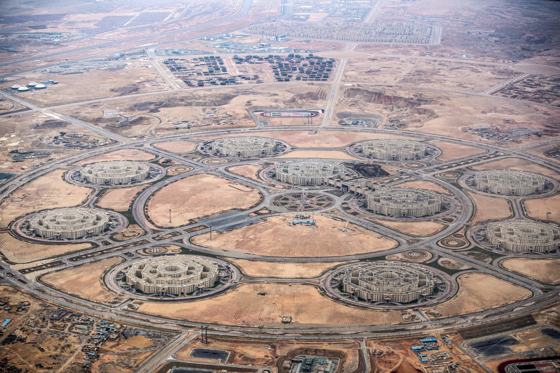
Located some 45 kilometers (28 miles) east of Cairo, the New Administrative Capital is Al Sisi’s crown jewel. Contractors began work on the project in 2015. When finished, the luxe megacity will be almost as large as Singapore and boast a series of artificial lakes, an amusement park four times the size of Disneyland, and the tallest skyscraper on the continent. But the first phase alone, slated for completion in 2022 (although engineers working on the project say that construction is far behind schedule), will cost $45 billion — an unfathomable sum to anyone, perhaps, but more dissonant still for the more than 60 million Egyptians who depend on shrinking subsidies for their daily bread.
The images of these projects have their own role in Egyptian politics. Television commercials starring Egyptian celebrities and billboards stationed along every road in the nation depict imagined lives in lush, gated communities backdropped by gleaming glass towers and bluer skies than dust-choked Cairo has ever seen. They are part of what architect Adham Selim describes as a practice of “ruling through drawing,” in which the government produces images of the future as a means of exerting greater control over the present and the past. “The continuous act of drawing the world-to-be is the way in which authority sustains a stable worldview, in which it places itself as an external to the world it intends to change, and rule,” writes Selim.
The regime is also invested in manufacturing an archive of visual media and material products that will last generations. Not wanting to be associated with political turmoil or the growing rates of incarceration, impoverishment, and hunger that have characterized its reign, the regime is writing its own history. “(The government) is reframing and remaking history,” says Khalil, “rewriting the story the way that it wants it to be told.”
Those who were once Egyptian secondary school students will recall the tales of former rulers — President Gamal Abdel Nasser nationalized the Suez Canal and built a dam to stop the floods, President Anwar Sadat crossed the canal and destroyed the Bar-Lev Line in the October War. Al Sisi longs to be remembered as the ruler who snatched Egypt from the mouth of the Muslim Brotherhood and built a new Cairo in its wake. To this end, he is curating an archive that will be taught in the future.
The history of Egypt is also a history of Cairo, of successive regimes struggling to establish order over a metropolis that one 19th century English traveler described as a city of “motley colored crowds.” Tahrir Square was built in the 19th century under Khedive Ismail as part of his grand modernizing vision for a “Paris on the Nile.” He named the square for himself — Midan Al Isma‘iliyyah.
But Ismail borrowed so excessively from foreign lenders to realize his vision that when a collapse in the price of cotton left Egypt unable to repay its debts, European powers had him deposed. Then Britain invaded Egypt to protect its interests, starting a decadeslong occupation. The square was renamed Tahrir, meaning liberation, after it became the focal point of the 1919 and 1952 Egyptian Revolutions.
The ongoing construction has more recent precedents as well. Successive Egyptian administrations have tried to decentralize Cairo, building generation after generation of satellite cities meant to entice upper- and middle-class Cairenes out of the urban core. The cities 10th of Ramadan and 6th of October, located east and west of Cairo, respectively, built under Sadat, and Madinaty and New Cairo (not to be confused with the New Administrative Capital), scattered to the east and started under Mubarak, sit half-empty, having never reached their target populations — or anything close.
A coiled network of new roads and bridges, the transfer of vital ministries to the periphery, and a vision for redeveloping areas on the banks of the Nile, which would have required the eviction and resettlement of as many as 12 million people, were all outlined under the Mubarak-era “Cairo 2050” urban redevelopment plan.
What is new, however, is the fervor and violence with which urban transformation is now being pursued. Yahia Shawkat, author of “Egypt’s Housing Crisis: The Shaping of Urban Space,” estimates that 33,000 families were victims of forced eviction under Mubarak between 1997 and 2012. Under Al Sisi, the Ministry of Housing now boasts that it has relocated 60,000 families between 2018 and 2020 alone. When the government cannot negotiate terms of relocation with unwanted residents, it has no qualms about resorting to force. “The state (has) decided that things will happen and will happen quickly and with the force of arms,” explains Higazy.
When the government wanted to demolish informal housing on Warraq Island, located in the center of the Nile river in Cairo and home to 90,000 people, it sent security forces with bulldozers in the predawn hours of July 16, 2017, while most residents were still asleep. Heba Nagaa Otmorsi, a resident of the island, told The Guardian that her house had been demolished while she was at work. “It was our neighbors who rescued the children,” she said. Clashes on the island left one resident dead and dozens injured.
Decades of rhetoric portraying informal or self-built neighborhoods as unclean or crime-infested aid the government in assuaging public outrage over their demolition. “People living in these semi-autonomous neighborhoods are always blamed for some sort of social urban ill,” says Shawkat, who has traced the discourse back several decades in his research.
Before security forces stormed Warraq Island, Al Sisi alleged to the press that buildings on an unspecified Nile island were leaking sewage into the river. “Yes, there are residents … but they have to be removed,” he told reporters.
While there are degrees to the violence, not even wealth nor wasta (an Arabic word loosely translated as connections) can protect communities from rampaging demolitions and construction works. In January 2021, several high-level government officials laid the cornerstone of the Cairo Eye in Zamalek, one of Cairo’s wealthiest neighborhoods. One-third of Al Masallah Garden, a 15,000-square-meter (16,500-square-yard) historic park, will be destroyed to make way for the 120-meter-tall (132-yards) observation wheel, surrounded by shops, entertainment, restaurants, and a two-story parking garage.
Even legally protected heritage sites, those marked for preservation under Egyptian law or UNESCO, are no longer safe. Recent projects have disrupted Khedival Cairo and Mamluk-era tombs in the City of the Dead. A recent announcement that graves around Imam Al Shafi’i Mosque will be moved to make way for a bridge project has left Hussein Omar heartbroken at the prospect of losing his family mausoleum, where generations have been laid to rest since his great-great-grandfather bought the plot in 1924. It feels like a “concerted assault on the fundamental relationship that Egyptians have with their past,” he says. A plot that has belonged to his maternal grandmother’s family since the 19th century is even nearer to the site of the scheduled bridge project. There is no way of knowing if either plot will survive the new construction.
The trauma of Cairo’s ongoing demolition and reconstruction gnaws at the city today. But even after it has subsided, it will have left scars on this centuries-old metropolis on the Nile — in its urban landscape, in the shape of bridges and roads built to last decades, and the satellite cities awaiting residents who may never come. So, too, in its fraying social fabric, as the ranks of the incarcerated, displaced, and impoverished grow, family histories are disrupted, and national debt balloons.
Let us not forget that the last Egyptian despot who set out to build a new Cairo did so at the expense of his nation’s independence.