


In November 2024, a ceasefire agreement brought a fragile and precarious state of calm to the border between Hezbollah-controlled southern Lebanon and Israel, after more than a year of cross-border military engagement that had escalated to become a full-blown conflict from September. According to a memorandum of understanding published by the United States and France, the U.S., in partnership with the United Nations, will facilitate indirect talks between the two countries to resolve remaining disputed points along the so-called Blue Line — a line drawn by U.N. cartographers in May 2000 to mark the Israeli military’s withdrawal from Lebanon, ending an 18-year occupation.
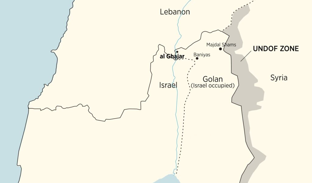
The purportedly temporary Blue Line has now existed for seven years longer than Israel’s occupation of southern Lebanon. It remains a source of political tension between Israel and Lebanon and of tremendous stress for the residents of the disputed border zone. Ghajar, a village populated by Alawites, controlled by Israel but claimed by both Lebanon and Syria, is the most serious point of contention. The Blue Line drawn by U.N. cartographers in 2000 split Ghajar in two. One part fell under Israeli control and the other on the Lebanese side of the U.N. line, with all the restrictions on movement one would imagine in a border region between two countries that are in a state of war. A line drawn on a map divided families and disrupted the lives of the villagers, who had lived as a cohesive community for centuries.
The story behind the partition of Ghajar brings together the colonial legacy of the modern Middle East, clumsy boundary demarcation, cartographic errors and manipulations, and intra-Arab and Arab-Israeli struggles over access to water within the context of the Middle East’s broader geopolitics. A critical element of this multifaceted story is maps, and how they led to the erroneous partition of Ghajar in 2000.
A tiny village with a population of 2,806, according to a 2022 census, Ghajar is situated on the eastern bank of the Hasbani River, between Syria, Lebanon and Israel. It is close to the western slopes of Mount Hermon and the source of the Jordan River. Israel occupied the village and the rest of the Golan Heights during the June 1967 war, extending its de facto frontier with Lebanon to include this area, which had previously formed part of the boundary between Syria and Lebanon, itself never officially demarcated. In December 1981, the Knesset, Israel’s parliament, passed the Golan Heights Law, which applied Israeli law to the area and gave Israeli citizenship to the residents of Ghajar. They identify as Syrian Alawites but are also fully integrated into Israel’s political and economic life. In addition to Arabic, they tend to be fluent in Hebrew, study in Israeli higher education institutions and work in industries in the north of Israel.
For centuries, Ghajar was a poor, remote village in the Damascus province of the Ottoman Empire. It became a Syrian village during the French Mandate, when temporary custodial rule was granted to France by the League of Nations following the collapse of the Ottoman Empire after World War I. France divided the region known as Greater Syria into Lebanon and Syria, imposing French rule over the two countries. The creation of the two states was an expression of both the French colonial practice of “divide and rule” and the aspirations of many Christians in Lebanon to establish a political entity separate from Syria.
On Aug. 31, 1920, Henri Gouraud, the first French high commissioner to Syria and Lebanon, issued Edict 318, announcing the establishment of Greater Lebanon, separate from Syria. While falling short of precisely demarcating the boundaries of this newly created state, the French used an 1862 French map, the “Carte du Liban,” to illustrate their intentions concerning its contours. Although a beautifully drawn map, the “Carte du Liban” was imprecise and its scale — 1:200,000 — was too small to be used for professional boundary demarcation purposes. Still, according to this map, the boundary line in the area that concerns us follows the Hasbani riverbed and curves eastward toward Mount Hermon north of Ghajar, placing the village squarely inside Syria. Because Syria and Lebanon have not, to this date, signed a formal boundary treaty, the imprecise French map drawn in 1862 is the only official document that shows the outlines of Lebanon’s boundaries as designed by France.
In 1936, the French finally produced a newer map of the region. Based on the Ottoman maps of Syria and Lebanon and still a relatively unprofessional cartographic endeavor, it placed the village of Ghajar inside Syria while identifying the Hasbani River as the boundary river between Syria and Lebanon, per the original intentions of the French in 1920.
The events of World War II exacerbated the cartographic confusion. In July 1941, British-led Allied forces conquered Syria and Lebanon, occupied at the time by Vichy France, an ally of Nazi Germany. In 1942, British authorities issued relatively high-quality, large-scale maps of Syria and Lebanon, but did a poor job of transferring essential cartographic data from the 1936 French map. The British map did not maintain the border as it had appeared in the 1920 and 1936 maps, which left Ghajar inside Syria and the Hasbani as a boundary line. It transferred the line in relation to the coordinate grid, rather than adjusting it to maintain the relative position between the border and geographical features. As a result, Ghajar appears on this 1942 map fully inside Lebanon, while south of the village the Hasbani River is placed in Syria, since the boundary line was drawn not inside the riverbed but west of it. Yet the error did not affect the people of Ghajar: The village remained Syrian, administered by Syria as part of the Golan Heights, while Lebanon’s unimpeded access to the Hasbani River continued as it had before the arrival of the British forces.
British dominance in map production during the colonial period, and the tendency of cartographers worldwide to copy borders from existing sources to save on research costs and avoid responsibility, resulted in cartographers from around the world, and even from neighboring countries, copying the erroneous border into their maps.
In 1963, newly drawn maps of Lebanon added the most consequential element to this cartographic history, bringing us closer to explaining the erroneous partition of the village in 2000.
The early 1960s are known as the years of the “water wars” between Israel and its Arab neighbors. Israel constructed its National Water Carrier to transfer water from the Sea of Galilee to the Negev desert, while Arab states were engaged in efforts to divert the sources of the Jordan River, placed in Syria and Lebanon, and prevent them from flowing into the Sea of Galilee in Israel. One of these sources was the Hasbani River, particularly the Wazzani Springs, placed just west of the northern part of Ghajar, inside the river’s canyon.
What is less known about the “water wars” is that, even as Israel and its Arab neighbors were battling over control of regional water resources, Lebanon and Syria were trying to determine usage rights for the three rivers they shared — the Asi, the Kebir and the Hasbani. It was in that context, in 1963, that Lebanese cartographers began to prepare a series of maps for the first time since the country gained independence 20 years earlier, which ended up having consequential repercussions for Ghajar.
The Lebanese cartographers surely knew the village was administered by Syria, but they chose to draw the border in accordance with Lebanon’s interests, especially concerning water resources. Southwest of Ghajar, they returned the boundary line to the Hasbani riverbed as in the French map of 1920, making the Hasbani a border river accessible to both Syria and Lebanon. But to make sure the Wazzani Springs, which form the most important source of the Hasbani, stayed fully in Lebanon, they deviated from the earlier French map. Instead of circling Ghajar north of the village and leaving it fully in Syria, they drew a line northeast, to the south of the springs, cutting through the village and leaving the northern half in Lebanon and the southern in Syria. Understanding that dividing the village on the map would produce an anomaly and might attract attention, they called the northern half of the village al-Wazzani, which created the false impression that it was a different village. The new map showed Ghajar in the south and al-Wazzani in the north. Since Ghajar was not physically divided, the villagers continued to live as they always had. No one told them that the new map showed their village divided in half. Ghajar was still de facto in the Golan Heights, which was under Syrian rule, administered from the Syrian district town of Quneitra.
Cartographers around the world, continuing the money-saving practice mentioned above of copying from existing maps, especially borders, did exactly this with the Lebanese maps. They copied the erroneous line placed by Lebanon’s cartographers in the Ghajar area, including the fictitious village of al-Wazzani. The line even appeared in Syrian and Israeli maps and eventually made its way into the U.N. maps.
On the ground, the villagers remained as they had before, in one undivided Ghajar, completely oblivious to the fact that, as of 1963-4, all the maps, including Israel’s post-1967 maps, showed their single village as two separate villages — Ghajar and al-Wazzani — partitioned by the Syria-Lebanon border. Their lived reality only changed in May 2000, when Israel made the unilateral decision to end its military presence in southern Lebanon, which it had occupied since 1982, and the U.N. demarcated the line of withdrawal.
According to the material provided by the Israelis to the U.N. cartographers, Ghajar was an integral part of the Syrian Golan Heights until the June 1967 war, which ended with Israel in control of the region — a situation that endures to this day. Yet the U.N. team decided to rely mainly on its own map, which copied the delineated border from the 1963-4 Lebanese map that showed Ghajar divided between Syria and Lebanon. The villagers, shocked to learn that the fate of their village was in question, refused to allow the U.N. team to enter Ghajar. Unable to observe on the ground that Ghajar was one undivided community, the U.N. team had only their maps to determine the course of the Blue Line. And so they drew the line through Ghajar, creating the humanitarian and security crisis that persists to this day. Google Maps currently shows the Blue Line running through the village, and perpetuates the false division, first created by the 1963-4 Lebanese map, of separating it into two distinct communities, the fictitious al-Wazzani in the north and Ghajar in the south.
The U.N.’s cartographic team said that they had drawn the Blue Line for pragmatic purposes, with a final decision regarding the international boundary to be determined by an agreement between the relevant states. After military engagement between Israel and Hezbollah began on Oct. 8, 2023, the U.S. suggested that a ceasefire agreement could also be used to resolve the remaining disputed points along the Blue Line, perhaps leading to a formal boundary treaty between Lebanon and Israel.
With a ceasefire agreement in effect, now is the time to free Ghajar’s residents from their imposed trauma and its ensuing consequences. However, it remains to be seen whether the U.N., which unknowingly perpetuated the mistakes of others and transferred them from the map to reality by dividing Ghajar, will correct its error. Removing this unnecessary point of contention along the Israel-Lebanon border would perhaps bring some justice to the village’s residents, ease their existential concerns and help reduce geopolitical tension.
Sign up to our mailing list to receive our stories in your inbox.