
Over the course of the 20th century, the population of Nubia — the region that straddles today’s Egyptian-Sudanese border — experienced the progressive flooding and destruction of their homes, as two dams were constructed just south of the Egyptian city of Aswan. The first, the “Khazan Aswan” (or Aswan Dam), was built and heightened during the century’s first few decades under British rule. The second — the larger and infinitely more destructive “al-Sadd al-Ali” (High Dam) — became a centerpiece of Gamal Abdel Nasser’s presidency as the structure took shape during the 1960s.
Nubia, archaeologists now suggest, had long been a region culturally entangled with the areas surrounding it. It was also an area whose population had a distinctive identity and way of life, a fact that the building of the dams helped to emphasize, as Nubian matters came more into the public eye. When construction of the first Aswan Dam began, however, Nubia found itself subject to Egyptian ideas of the “unity of the Nile Valley” and of maintaining an Anglo-Egyptian Sudan (founded in 1899), which was dominated by the northern country and its British overlords.
Consequently, it should come as no surprise that the work of damming at Aswan engendered the forced migration of Nubians. At the same time, by simultaneously stimulating archaeological surveys and preserving Nubia’s soon-to-be flooded ancient remains, the construction of the dams created and solidified a colonial view of the region’s past. The Nubian (non-)role in the process resounds with loud, clear and contentious reverberations today. Classing Nubians as racially degenerate, both colonial and postcolonial officials prioritized Pharaonic and Greco-Roman history and archaeological work in the region, which meant that Nubia’s past — and heritage — have never been seen as “Nubian.” As Nubians themselves become increasingly vocal about their plight, however, and demand a “right to return,” the question is: Can that heritage ever be theirs? Likewise, can anything from the Nubian archaeological projects be salvaged to help address this question?
The destruction caused by the successive dams at Aswan was meticulously documented, largely with a view to the ancient sites. Yet, as I combed through archives relating to that work, other versions of Nubia came into view. Here was the disappeared Nubia, clearly showing what contemporary accounts and history alike have chosen to ignore, with photos of Nubian settlements alongside photos of the non-Nubian remains taken so seriously. Many different actors played a role in the sidelining of the Nubians themselves by eliminating their culture from the narratives created of the area, including anthropologists, archaeologists and politicians, whether colonial or revolutionary. Today, their actions are increasingly being called into question.
For millennia, Nubian life had been lived across the then-fluid border of Egypt and (the once Anglo-Egyptian) Sudan. When these two countries signed the Nile Waters Agreement of November 1959 and approved the High Dam’s construction, officials in both places made plans for the resettlement of their respective Nubian populations. Nubians would henceforth become significantly less mobile. Tied to two new nation-states — and a border that would soon be flooded — Egyptian and Sudanese Nubians (as they had become known) would be firmly entangled within burgeoning and developmentalist national identities. Such developmentalism both propelled the High Dam’s construction and promoted very particular visions of past, present and future.
In Sudan, officials led by Wadi Halfa District Commissioner Hassan Dafalla planned for Nubians to move to a new settlement and land reclamation scheme at Khashm el-Girba, many hundreds of miles to the southeast on the Atbara River. Dafalla later published a book about the project and its population surveys named “The Nubian Exodus.” That move happened from 1963 until 1965, despite demonstrations at Wadi Halfa, which not only meant that some Nubians remained living in hardship in temporary structures built out of railway ties but also that, from 1970 onward, Sudan’s government rebuilt the Egyptian-Sudanese border town above the High Dam’s floodwaters.
In Egypt, meanwhile, officials made plans for the country’s Nubians to migrate to the planned settlement of New Nubia, or al-Nuba al-Jadida. Located 30 miles north of Aswan at Kom Ombo, this new home (other than playing a central role in the Upper Egyptian sugarcane industry) is most famous elsewhere for a Greco-Roman temple dedicated to the crocodile god Sobek. This temple is a favorite stopping point of the Nile cruises that have long formed a part of Egypt’s tourism industry and is one of many iterations of the “eternal” ancient Egyptian imagery that helps to power it. When, during 1963 and 1964, Egypt’s Nubians found themselves forced to move there, their place in relation to that vision of Egypt coalesced into a vision in which their regional past was subsumed into the wider whole. Of course, the wider region had long been subsumed into ideals about Egypt’s dominance of the Nile Valley.
Plans for the High Dam had originally been proposed in 1947, before the July 1952 Free Officers’ coup that ultimately led to Nasser’s presidency and the 1953 referendum that sanctioned Sudanese independence. However, the dam’s links to the Nasserist moment now became irresistible. Here, built with the aid of Soviet expertise (after Britain, the United States and the World Bank withdrew support for the project in 1956), was a “new pyramid” of Egypt. The Egyptian state, meanwhile, cast Nubians as willing victims of its construction: “living relics,” almost, of what everyone else depicted as a premodern — and prerevolutionary — time, now traveling north to a new and better future.
Not providing much consolation to the Nubians, Nubian life would be recorded. In Egypt, the records would be subject to a Ford Foundation–funded “ethnological survey,” based at the American University in Cairo, and to smaller-scale ethnological work conducted on behalf of the Sudan Antiquities Service. Yet what seemed to matter most (whether to the Egyptian and Sudanese governments or to numerous different people and institutions) were the other relics that the country’s Nubians lived among: archaeological sites and ancient temples dating originally to the Pharaonic and Greco-Roman eras.
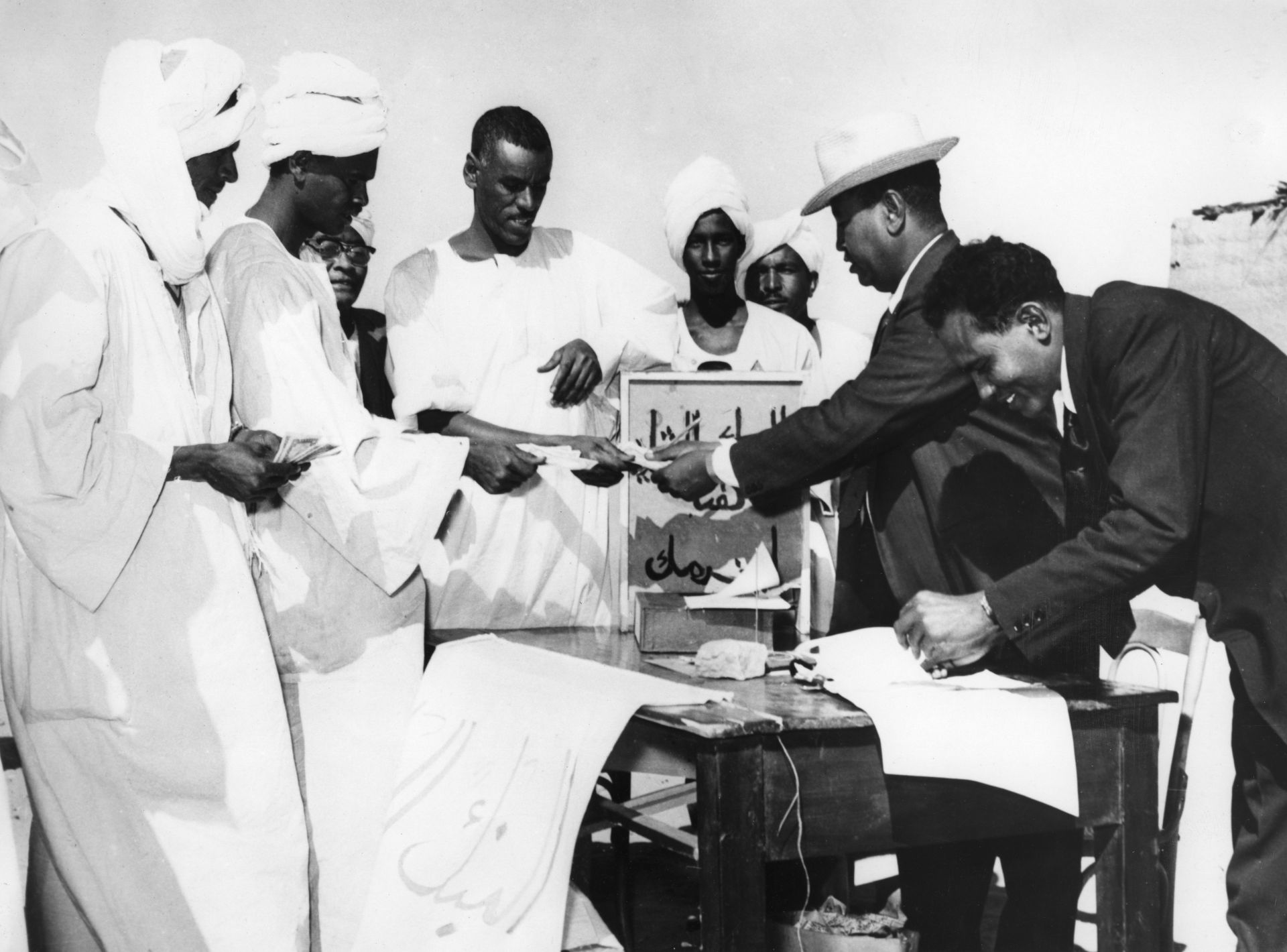
In 1960, at the request of the Egyptian and Sudanese governments (and with the backing of many other countries, most notably France and the U.S.), UNESCO launched its International Campaign to Save the Monuments of Nubia. Today, the Nubian campaign is most famous for the cutting up, movement and reassembly of the temples of Ramses II and Nefertari at Abu Simbel above the floodwaters in Egypt and the similar action carried out on the Greco-Roman temple complex located on the Egyptian island of Philae. The campaign finally ended in 1980 and became connected to the development of UNESCO’s 1972 World Heritage Convention.
Less discussed, however, is that the priorities of the project to dam the Nile had a colonial history: one that made possible the campaign’s preference for ancient ruins over people. The High Dam’s prerevolutionary origins in much older schemes for the utilization of the Nile help to explain why. Those schemes included the original Aswan Dam, which was built and heightened over the early decades of the 20th century. Its floodwaters themselves caused a process of (Egyptian) Nubian migration, both to higher ground and, in some cases, to domestic work in Cairo and Alexandria.
When British authorities of the Egyptian “veiled protectorate” (whereby the colonial power ruled the Egyptian rulers) authorized construction of the Aswan Dam in 1898, concerns about the flooding of Nubia’s ancient ruins became as clear as they would again 60 years later. Subject as the ruins already were to the vagaries of the Nile’s annual inundation, now the potential for the flooding of those structures would become worse. The temple complex of Philae (known as the “Pearl of the Nile”) was located on an island just to the dam’s south, and officials consequently limited the new barrage’s height after French public outcry about the possibility of the island’s total deluge by the reservoir that would be formed north of it.
After construction of the dam finished in 1902, however, officials made plans for the structure’s heightening almost immediately. The British quest to enable perennial irrigation of the Egyptian Nile knew no bounds: Doing so would increase the occupied territory’s agricultural productivity and help repay the debt that had been one reason for the British occupation of 1882.
The ruins of Nubia would have to suffer. At the same time, however, officials in Egypt’s Ministry of Public Works — overseer both of the dam and of the country’s Antiquities Service — continued to enjoy a soft spot for the ancient Nile-side remains. Attuned as the Egyptian officials were to viewing those remains from the decks of the steamers that plied the river, the vision of a ruined, riparian Nubia was one that continued to appeal. Officials were torn between the benefits of modernization and their enjoyment of the Egyptian past.
Consequently, as heightening of the Aswan Dam began in 1907, the Antiquities Service organized an archaeological survey of the Egyptian Nubian sites that were due to be flooded. Taking place first under the direction of the U.S. archaeologist George Reisner, then the British archaeologist Cecil Firth, the survey concluded in 1911. Yet that date did not represent an end to either damming or archaeological work. In the years after 1922, when Britain declared Egypt’s (nominal) independence, the Egyptian government ordered the further heightening of the dam, which took place for the second time from 1929 until 1933. Again, the floodwaters to the south of the structure would rise, and again the Antiquities Service organized an archaeological survey to mitigate the destruction those waters would cause, this time led by the British archaeologist Walter Emery.
As the dam’s floodwaters forced Egypt’s Nubians to move their homes higher up the Nile’s banks, both of these surveys cemented an overriding image of the region’s ruination. Constructing a vision of partially flooded temples and archaeological sites and of a place once dominated by ancient Egyptian civilization, the surveys echoed both the racial tropes of contemporary Egyptological thought and the racial ideas that helped drive the building of modern Egypt. This is a long and complex story. Familiar from all racial narratives relating to Egypt, however, was the presumed backwardness of the Nubians. Thus they were ripe for sublimation into new Egyptian glories. These new images of glory ensured that the country’s liminal southern region (and, beyond that, Sudan) would be dominated by its north, whose fortunes, considered great in antiquity, would either be revivified by Egyptians or the territory’s British occupiers, depending on who was doing the telling. Nubia’s ancient glories, meanwhile flooded and ruinous, took center stage in popular representations of the region, geared as they were toward political and tourist profit.
Thirty years later, as UNESCO’s Nubian campaign sought to record and preserve the archaeological sites and temples on both sides of the Nubian border, a vision of picturesque — and sometimes salvageable — ruin took hold. Among many others, Walter Emery would play a central role in the work in both countries. Thus, in 1964, when the first stage of the High Dam was completed and the last annual inundation of the Egyptian Nile took place, the barrage’s floodwaters began to submerge Nubia’s ruins permanently, even as workers continued to take certain structures apart and move the pieces of temples to storage on dry ground. Those structures found themselves reassembled in Egypt, Sudan and farther afield, often to spectacular acclaim. Among other international moves, one need only think of the temple of Dendur at the Metropolitan Museum of Art in New York.
At the same moment, however, the Nubian settlements that had been located next to and around these ruins were subject to forced abandonment and were left to lie under a reservoir named Lake Nasser in Egypt and Lake Nubia in Sudan. Nubians seemed to have little connection left to these places in the eyes of the international cast of experts who helped to organize the work and define what heritage was, let alone the governments who wanted them enfolded safely within new nation-states.
What connections might be made to these places, moreover, depended on the ability of the concerned national governments to represent them in the multilateral institution that had come to help seal their fate. In 1979, UNESCO added the second set of sites to its new World Heritage List. Among the places added were the “Nubian Monuments from Abu Simbel to Philae,” a geographical description taking only Egyptian Nubia into account. Sudan did not manage to get anywhere on the World Heritage List until 2003, which is a reflection of the instrument’s dependence on state action.
Nubia, however, never truly disappeared. Alongside the excavation and preservation of huge amounts of material culture, the Nubian campaign (and its connection to the development of World Heritage) was nothing if not a process of creating massive archives, documentary and photographic. Pictures taken during UNESCO’s project in particular tell a different story from that of the disconnect between Nubia’s past and present that many accounts of the region, then and now, like to relate.
Whether inadvertently or intentionally, such photos often document the close relationship between Nubian settlements and the region’s ruins, in addition to visualizing the people who lived there — and who sometimes worked to take ruined structures apart. Stored in archives used by archaeological researchers, these records have mostly been used to narrate ancient archaeological and monumental pasts. Within themselves, however, they hold the key to why assertions of Nubian identity remain contested.
These photos are one of the forms in which “Nubia still exists,” as the scholar Menna Agha has noted. Combing through the photo archive of the German Archaeological Institute in Cairo, I came across many such examples of this slippage in time. For example, I viewed many images of the disassembly and reconstruction of the Egyptian Nubian temple of Kalabsha, built during the reign of the Roman emperor Augustus. Kalabsha today stands clustered with a group of other reconstructed temples on the island of “New Kalabsha,” just south of the High Dam; it was originally located about 30 miles to the new barrage’s south. Archival photos, however, illustrate the original proximity of the temple to the settlement of Kalabsha in a way that makes the entanglement of the two clear.
Since the construction of the first Aswan Dam, Nubian cultural associations have always existed, not least in Cairo. Such organizations serve as a meeting point for the Nubian community living in the city. Within certain bounds, they also work to represent Nubians to the government, media and other institutions.
Cairo’s Society for Nubian Heritage, for example, was consulted on the ethnographic displays in Aswan’s Nubia Museum, which opened in 1997 and was a follow-up project to UNESCO’s Nubian campaign. The reaction to that process from at least one of the society’s members was far from positive: UNESCO and the Egyptian government “didn’t listen to a thing we said,” reported the anthropologist Elizabeth A. Smith. Nevertheless, in 2019, the society became a consultative body to the International Governmental Committee of UNESCO’s Intangible Cultural Heritage program. Nubians are engaged with institutions that, at times, have hurt them.
The final years and aftermath of the presidency of Husni Mubarak saw calls for Nubian rights grow stronger. Younger Nubians in particular saw Egypt’s political shifts as an opportunity not only to make demands for such rights but also to make the case for a “right to return” to control of the land around the High Dam’s reservoir. This shift in strategy yielded Article 236 of Egypt’s 2014 Constitution. If nothing else, this article gives Nubians — and residents of other Egyptian “border and underprivileged areas” — the right to return to their former lands via the specific medium of development projects.
Unfortunately, the appearance of this Article did not lead to its application. In 2014, the government of Abdel Fattah al-Sisi promulgated Presidential Decree no. 444, which decided that 16 Nubian villages located on the Egyptian border should become military territory. This decree means that, even if action were taken in relation to Nubian development, that land could no longer be part of the work and Nubians could no longer return to it.
Nubians, whether in Egypt or in Sudan, remain sidelined. The deeper history of this sidelining, however, is one that needs to acknowledge the roles of archaeology, anthropology and heritage practice in creating the neglect. Together with irrigation programs, over the course of the 20th century, those disciplines helped to create the conditions that produced Nubian marginalization.
Sign up to our mailing list to receive our stories in your inbox.